Property Record
6851 Overhills Rd, Spring Lake, NC 28390
NEARBY LISTINGS FOR SALE OR LEASE
-
-
View all Spring Lake listings for sale on LoopNet.com
Property Detail
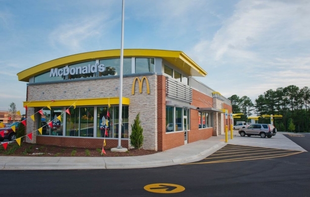
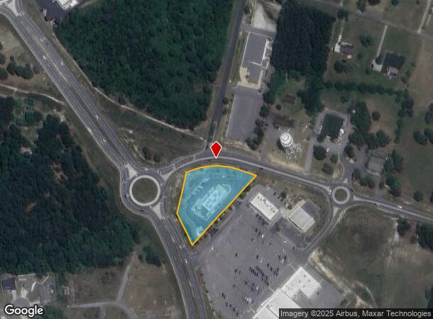
6851 Overhills Rd
Dunn, NC
R Anderson Crk
01050501 0300 99
LT#4R ANDERSON CRK SHP CTR 1.561ACS MAP#2012-594
Restaurantdrivein
Harnett
X
North Carolina
3720050400J
4r
2024
1.56 AC
2024
Fayetteville MSA
071202
Other Market Areas
5,454 SF
DEMOGRAPHICS near 6851 Overhills Rd
1 Mile
3 Mile
5 Mile
2024 Total Population
4,301
16,602
37,946
2029 Population
4,783
18,437
41,516
Pop Growth 2024-2029
+ 11.21%
+ 11.05%
+ 9.41%
Average Age
33
34
33
2024 Total Households
1,486
5,763
12,909
HH Growth 2024-2029
+ 11.44%
+ 11.33%
+ 9.48%
Median Household Inc
$69,160
$75,392
$74,942
Avg Household Size
2.90
2.90
2.90
2024 Avg HH Vehicles
2.00
2.00
2.00
Median Home Value
$207,091
$226,492
$224,537
Median Year Built
2003
2004
2004
Nearby Places
- Restaurants
- Banks
- Shops
- Fitness
- Groceries
PUBLIC TRANSPORTATION
AIRPORT
Fayetteville Regional/Grannis Field
DRIVE
WALK
Distance
Fayetteville Regional/Grannis Field
37 min
22.7 mi
Freight Ports
Port of Wilmington
DRIVE
WALK
Distance
Port of Wilmington
153 min
108.4 mi
Nearby Properties
Address
Land Use
TOTAL SIZE
Lot Size
Zoning
Address
Land Use
TOTAL SIZE
Lot Size
Zoning
54.49 AC
RA20M
Address
Land Use
TOTAL SIZE
Lot Size
Zoning
30.82 AC
RA20M
Address
Land Use
TOTAL SIZE
Lot Size
Zoning
37.95 AC
RA20M
Address
Land Use
TOTAL SIZE
Lot Size
Zoning
8,989 SF
5.94 AC
RA20R
Address
Land Use
TOTAL SIZE
Lot Size
Zoning
165.81 AC
RA20R
Address
Land Use
TOTAL SIZE
Lot Size
Zoning
22,464 SF
17.65 AC
RA20R
Address
Land Use
TOTAL SIZE
Lot Size
Zoning
21,273 SF
12.14 AC
RA20R
Address
Land Use
TOTAL SIZE
Lot Size
Zoning
147 AC
COMM
Address
Land Use
TOTAL SIZE
Lot Size
Zoning
187.10 AC
COMM
Address
Land Use
TOTAL SIZE
Lot Size
Zoning
1,360 SF
5.09 AC
COMM
Address
Land Use
TOTAL SIZE
Lot Size
Zoning
7,575 SF
8.70 AC
Address
Land Use
TOTAL SIZE
Lot Size
Zoning
13,103 SF
2.96 AC
Address
Land Use
TOTAL SIZE
Lot Size
Zoning
1.81 AC
CP-PLANNED
Address
Land Use
TOTAL SIZE
Lot Size
Zoning
8,988 SF
2.98 AC
RA20R
Address
Land Use
TOTAL SIZE
Lot Size
Zoning
9,100 SF
2.09 AC
COMM
Address
Land Use
TOTAL SIZE
Lot Size
Zoning
2,792 SF
9.62 AC
AG-20
Address
Land Use
TOTAL SIZE
Lot Size
Zoning
11,060 SF
5.19 AC
RA20R
Address
Land Use
TOTAL SIZE
Lot Size
Zoning
3,116 SF
1.58 AC
COMM
Address
Land Use
TOTAL SIZE
Lot Size
Zoning
30.31 AC
Address
Land Use
TOTAL SIZE
Lot Size
Zoning
40.15 AC
RA20R
Address
Land Use
TOTAL SIZE
Lot Size
Zoning
6,420 SF
1.07 AC
RA20M
Address
Land Use
TOTAL SIZE
Lot Size
Zoning
157.62 AC
RA20M
Address
Land Use
TOTAL SIZE
Lot Size
Zoning
6,120 SF
2.04 AC
COMM
Address
Land Use
TOTAL SIZE
Lot Size
Zoning
12,342 SF
2.28 AC
RA20R
Address
Land Use
TOTAL SIZE
Lot Size
Zoning
4,312 SF
2.11 AC
RA20M
Address
Land Use
TOTAL SIZE
Lot Size
Zoning
7,480 SF
2.09 AC
RA20M
Address
Land Use
TOTAL SIZE
Lot Size
Zoning
2,000 SF
1.65 AC
RA20R
Address
Land Use
TOTAL SIZE
Lot Size
Zoning
2,539 SF
0.93 AC
RA20R
The World's #1 Commercial Real Estate Marketplace
Connect with us
© 2025 CoStar Group
The information above has been obtained from sources believed reliable. While we do not doubt its accuracy we have not verified it and make no guarantee, warranty or representation about it. It is your responsibility to independently confirm its accuracy and completeness. Any projections, opinions, assumptions, or estimates used are for example only and do not represent the current or future performance of the property. The value of this transaction to you depends on tax and other factors which should be evaluated by your tax, financial, and legal advisors. You and your advisors should conduct a careful, independent investigation of the property to determine to your satisfaction the suitability of the property for your needs.